Difference between revisions of "Canyon Map/Gateburg"
From B.E.R.T. Wiki
| Line 35: | Line 35: | ||
<imagemap>Image:Gateburg_Neighborhood.png | <imagemap>Image:Gateburg_Neighborhood.png | ||
| − | poly 22 136 176 76 238 264 132 272 68 192 [[ | + | poly 22 136 176 76 238 264 132 272 68 192 [[|A1]] |
| − | poly | + | poly 318 52 360 204 336 232 300 240 272 266 236 256 186 90 [[|A2]] |
| − | poly 374 386 440 388 478 232 436 236 408 230 388 238 [[ | + | poly 374 386 440 388 478 232 436 236 408 230 388 238 [[|A6]] |
| − | poly | + | poly 372 260 348 384 208 358 164 312 198 304 264 324 338 312 [[|A5]] |
| − | poly 238 388 410 416 394 578 [[ | + | poly 238 388 410 416 394 578 [[|B1]] |
| + | poly 448 26 314 54 362 202 416 188 466 204 494 188 [[|A3]] | ||
| + | |||
</imagemap> | </imagemap> | ||
Revision as of 21:17, 29 June 2018
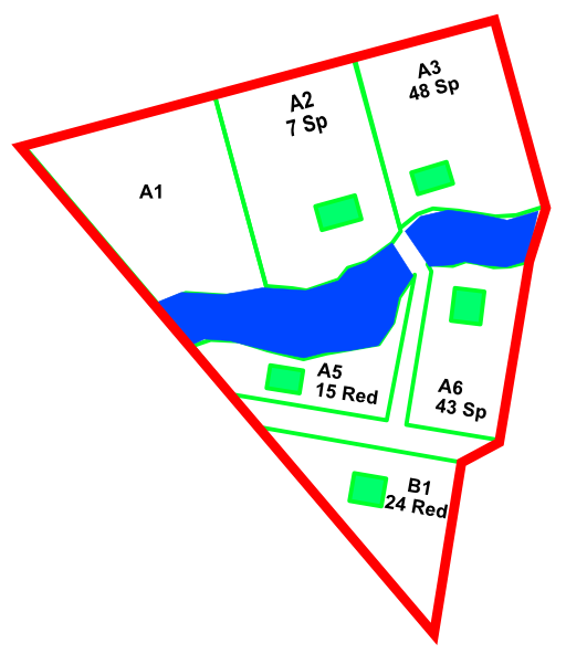
Gateburg
Gateburg is on the Northside of Redwood, just as you enter.
Neighborhood Coordinator
Catherine Peery 879-0078
Special Notes
- There is a once-car-bridge-now-foot-bridge here.
- There may be an escape route to the Girl Scout Camp's "Laurel Meadow"
- There is a yurt up on the slopes of A1. It is visible from the tentative escape route
Lots
- A1 : random Yurt Conroy, Curt 743-5502
- B1 : 24 Redwood Gutierrez, Rafael & Arduth 879-1155
- A2 : 7 Spruce Perry, Catherine 879-0078
- A3 : 48 Spruce Schumacher, Paul 879-0169 & Johnson, Tory 879-0169
- A5 : 15 Redwood Morrow, Scott 879-1800 Cherniss, David 879-1800
- A6 : 43 Spruce? Redwood? Kelley, Mark & Marnie 879-0728
( note: it's easy enough to strip property owner names before generating this PNG. Casey also needs to trim the PNG down, too much white space. This is from Greg's work. )
this is a screenshot -
Image:Gateburg_overview.png|frameless|upright=3|alt="Gateburg"|Gateburg
( needs image map applied. this next is a SVG but the image poly is 'offfff' )

of course a PNG, then we have to worry about scale
Error: Invalid title in link at line 2.

trying a raw SVG with an A reference
